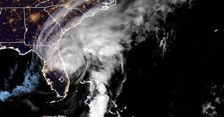
Tropical Storm Ian continued to move east across Florida early Thursday and could cause “catastrophic flooding,” forecasters warned.
Ian made landfall in southwest Florida as a major Category 4 hurricane, just short of a Category 5 hurricane, one of the strongest hurricanes ever to hit the U.S.
It left people trapped in their homes and large swaths of the state without power. About 2.5 million homes and businesses were in the dark as of 5 a.m. EDT, according to poweroutage.us.
The National Hurricane Center in Miami said the center of Ian “is expected to move off the east and central coast of Florida later today and then approach the coast of South Carolina on Friday. The center will move further inland through the Carolinas late Friday and Saturday . . . . Slight re-intensification is forecast and Ian could approach hurricane strength as it nears the South Carolina coast on Friday. Weakening is expected Friday night and Saturday after Ian moves inland.”
The center warned that “widespread, life-threatening catastrophic flash and urban flooding, with severe and record flooding along rivers, will continue in central Florida. Widespread significant flash, urban and river flooding is expected in parts of northeast Florida, southeast Georgia . . , and eastern South Carolina tomorrow through the weekend.”
https://www.cbsnews.com/live-updates/hurricane-ian-florida-damage-forecast-path-2022-09-29/


